

Satellites reveal many secrets of the Earth. Researchers are now indebted to a hiker and his enthusiasm for Google Maps for a new discovery.
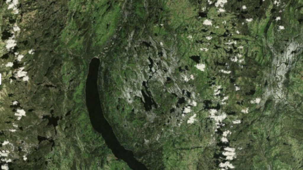
What did the hiker discover? In search of his next hiking destination, Canadian Joël Lapointe unknowingly scrolled through a sparsely populated area of Canada via Google Maps, about 100 kilometers north of the city of Quebec. Then he paused; a rounded structure stood out in the landscape: 15 kilometers in diameter, with a ring-like arrangement of smaller mountains in the center.
What followed is likely to result in an expedition by scientists in 2025 that aims to thoroughly investigate the origin. The creator of the depression likely came from the depths of space, an asteroid. Until now, volcanism was considered the most probable origin of the depression at Lake Marsal
. The small lake is located in the midst of the 8-kilometer inner hill ring.
CBC reports on the events, and a summary from the researchers can be found here on hou.usra.edu.
USB sticks in walls also seem mysterious. However, the explanation is quite mundane yet still exciting:
Volcanoes or an asteroid?
Unsure of what he saw but with a gut feeling that he had discovered something interesting, he contacted scientists from the Center for Earth Sciences and Environment
in Aix-en-Provence, France.
What do the scientists think? Upon viewing the images and analyzing soil samples, his suspicion was confirmed: An asteroid could have landed here, and based on initial assumptions, it might be the largest one discovered since 2013.
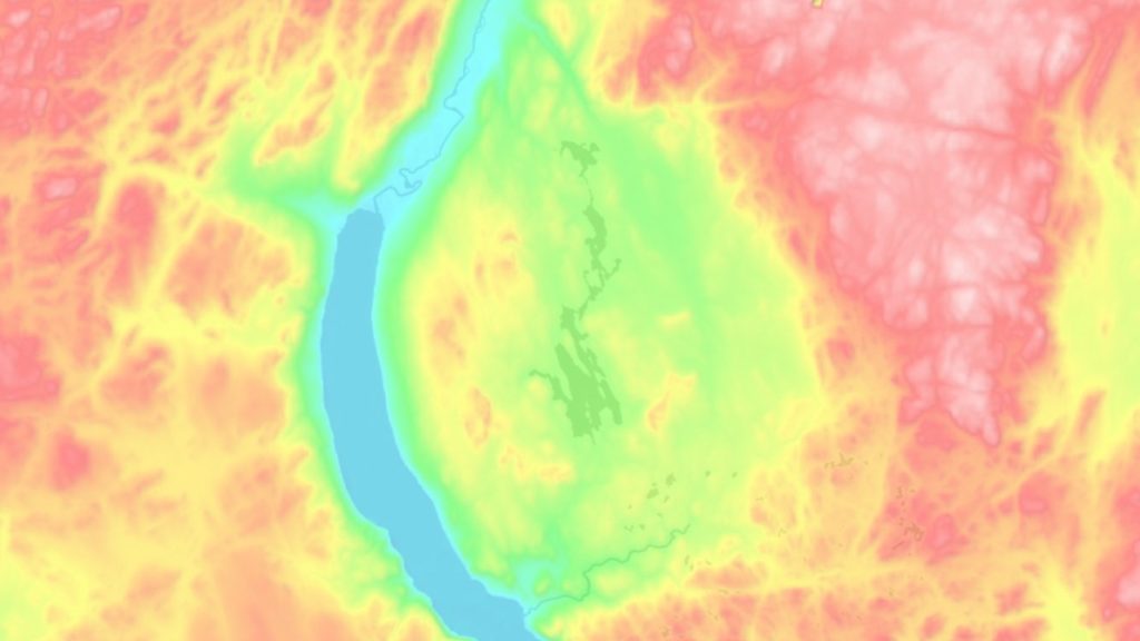
What may only be hinted at by amateurs in the satellite image is unmistakable on the topographic map. The round-oval depression in the landscape with the inner, elevated ring. The orange-red crater rim indicates a height difference of about 200 to occasionally even 300 meters. The dark green area in the center is the present Lake Marsal
.
Where do the soil samples come from? In the region north of Quebec, there is extensive mining, and the soil was previously examined. Thus, scientists were able to rely on scattered soil samples from the area, which contain at least some zircon. This mineral often forms during asteroid impacts as it is essentially melted
by the enormous heat.
What exactly impacted there? Very little is currently known about the hard facts of the presumed impact. Based on available soil samples, researchers estimate the age of the crater to be between 38 and 450 million years. Only a thorough examination of the site, including the collection of additional samples, is likely to allow reliable statements. Currently, the asteroid impact, despite strong indications, remains a hypothesis.
In 2025, the cooperating researchers from several universities are therefore planning an expedition. They are currently applying for the necessary funding.


Is every “circle with a depression” on Google Maps and similar platforms a crater? No, this is clarified by expert Gordon Osinski. He is a professor of Earth sciences at Western University in Canada and was consulted by CBC. In nine out of ten cases, they are not impact craters, but rather results of other processes like volcanism or weathering.
Mysteries exist not only on Earth, but also, especially for scientists, in the vastness of space. The crater in Canada is likely almost boring compared to the following puzzle. Researchers are currently faced with a riddle that challenges the boundaries of terrestrial physics research. We receive a signal from space every hour that should not actually exist.

Your opinion is important to us!
Do you like the article? Then let us know!